Hi everyone,
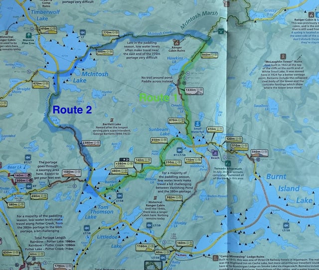
In about 1.5 weeks (2nd week of September) I’m heading off on a 3.5 day loop starting from the Canoe Lake access point, going through Burnt Island, Big/White Trout Lakes, Tom Thompson Lake and then back to the access point. It seems like it’s a pretty common loop. I’ve been reviewing the portage through Hawkins Lake/Canada Jay/Sunbeam, ending up at Tom Thompson Lake (route 1 on Maps by Jeff!), but after looking at satellite images this part looks pretty challenging!
Alternatively, I’m considering going through McIntosh Creek/McIntosh Lake (route 2). After hours and hours of googling, only to find a few sentences describing these portages I’ve realized that I should probably reach out and ask for some assistance as both routes seem to have their fair share of issues.
Some quick additional info – I’m doing this solo, I’ve been to Algonquin a few times and have done part of this loop before but only to Burnt Island and then back via the same route. I’ve done many kayak trips over the last decade or so, but this is the probably the most challenging one I’ve done so far. I’m excited to get back again but know how simple some areas of the park appear from maps etc, but the reality can be pretty different!
If anyone has any experience doing these portages, especially considering current water levels, I’d be extremely appreciative of your thoughts! I really just want the easiest/least risky route.
Thanks! 🙂
https://i.redd.it/lx6h35fn74nh1.jpeg
Source: r/algonquinpark · by /u/DrunkOnEspresso