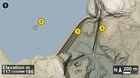
Bare-earth lidar shows the whole shape of Winsor Dam, an earth fill embankment of roughly 4 million cubic yards, 2,640 ft long and 170 ft above the Swift River. It holds back the Quabbin Reservoir, Boston's water supply. In April 1938 Massachusetts disincorporated Dana, Enfield, Greenwich and Prescott so the valley could go under, and around 2,500 people lost their homes.
Work ran from 1935 to 1939 under chief engineer Frank E. Winsor, who it's named for.
The dam is the long diagonal embankment from the bottom middle to the top, with the stepped downstream face showing as parallel bands.
Winsor Dam's earth embankment across the Swift River valley
Same view as plain hillshade with elevation tint
Air photo of the same area, August 2023
Numbered pins on picture 1:
Pin 1: The dam's stepped downstream face
Pin 2: Flat Quabbin Reservoir surface
Pin 3: A deep straight cut channel
Lidar: USGS 3D Elevation Program (3DEP), public domain.
Imagery: USGS The National Map (NAIP Imagery service), 2023, Public domain.
https://www.reddit.com/gallery/1x0nu70
Source: r/LiDAR · by /u/Northing_Labs